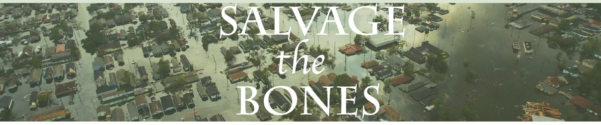
HURRICANE KATRINA: THE STORY
PRE HURRICANE
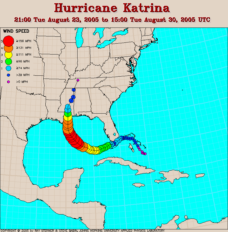
TUESDAY, AUGUST 23, 2005
5 p.m.: The National Hurricane Center in Miami, Florida issues an advisory on a tropical storm. It has formed over the Bahamas, about 350 miles east of Miami.
The National Hurricane Center defines a tropical storm as "a tropical cyclone in which the maximum sustained surface wind speed ranges from 34 kt (39 mph or 63 km/hr) to 63 kt (73 mph or 118 km/hr)".
WEDNESDAY, AUGUST 24
11 a.m.: The storm is growing stronger and more organized. The storm has been named Tropical Storm Katrina, the 11th storm named in 2005. Her strongest winds are about 40 miles an hour.
FUN FACT: Some of the other named storms in 2005 included Tropical Storm Arlene, Tropical Storm Bret, Hurricane Cindy, Hurricane Dennis, Hurricane Emily, Tropical Storm Franklin, and Hurricane Irene.
THURSDAY, AUGUST 25
5 p.m.: Katrina is now a Hurricane. Her strongest winds have increased to about 75 miles an hour, making her a Category One hurricane. The storm is about 15 miles east of Fort Lauderdale, Florida, and is about to strike land.
The National Hurricane Center defines a Hurricane as "a tropical cyclone in which the maximum sustained surface wind (using the U.S. 1-minute average) is 64 kt (74 mph or 119 km/hr) or more. The term hurricane is used for Northern Hemisphere tropical cyclones east of the International Dateline to the Greenwich Meridian. The term typhoon is used for Pacific tropical cyclones north of the Equator west of the International Dateline."
KATRINA HITS FLORIDA
7 p.m.: The eye of the storm hits North Miami Beach and Hallandale Beach on Florida's coast. The strongest winds are now 80 miles an hour. Two people are reported dead due to a falling tree caused by Katrina's winds.
FRIDAY, AUGUST 26
1 a.m.: Katrina initially weakens back down to a tropical storm. Her strongest winds decrease to 70 miles an hour.
3 a.m.: The storm comes out of the Florida peninsula and starts to strengthen almost immediately as it reaches the Gulf of Mexico's warm waters.
5 a.m.: Katrina is now reclassified as a hurricane. Her strongest winds are 75 miles an hour.
According to NASA "Tropical cyclones are like giant engines that use warm, moist air as fuel. That is why they form only over warm ocean waters near the equator. The warm, moist air over the ocean rises upward from near the surface. Because this air moves up and away from the surface, there is less air left near the surface. Another way to say the same thing is that the warm air rises, causing an area of lower air pressure below.
Air from surrounding areas with higher air pressure pushes into the low-pressure area. Then that "new" air becomes warm and moist and rises, too. As the warm air continues to rise, the surrounding air swirls in to take its place. As the warmed, moist air rises and cools off, the water in the air forms clouds. The whole system of clouds and wind spins and grows, fed by the ocean's heat and water evaporating from the surface."
KATRINA PROPELLED TOWARDS THE MAINLAND
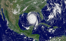
11:30 a.m.: The National Hurricane Center reports that a hurricane is "rapidly strengthening" as it's traveling through the Gulf of Mexico, being propelled by its warm waters. In a matter of hours, Katrina's strongest winds will be estimated to be at about a hundred miles an hour. Later that day Governors Kathleen Blanco of Louisiana and Haley Barbour of Mississippi officially declare a state of emergency for their respective states.
SATURDAY, AUGUST 27
SUNDAY, AUGUST 28
2 a.m.: Hurricane Katrina's winds are now 145 miles an hour. She is classified as a Category Four storm. The eye of the storm is now approximately 310 miles south of the mouth of the Mississippi River.
9:30 a.m.: Ray Nagin, the Mayor of New Orleans, issues a mandatory evacuation. Tens of thousands begin leaving the city.
11 a.m.: Katrina is now one of the most powerful storms ever recorded in the Atlantic. Her winds blow at about 175 miles an hour. She is now a Category Five storm. The eye of the storm is now about 225 miles from the Mississippi River.
FIRST SIGNS OF THE STORM
9:15 p.m.: The mayor of Biloxi, Mississippi, A.J. Holloway, says his city is "getting some rain, a little wind, and some lightning and thunder" from the hurricane. (Holloway survived Hurricane Camille in August 1969. He worries that Katrina may be even more catastrophic and that new residents have no idea what they are soon going to be facing. Residents that did not evacuate seek shelter in the New Orleans Saints' Superdome.
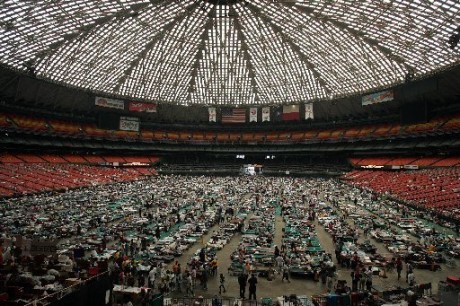
Approximately 9,000 residents and 550 National Guardsmen spent the night of the hurricane inside the Superdome. The number rose to 20,000 as more refugees were brought to the Superdome after search and rescue efforts. The roof of the Superdome had been estimated to withstand winds up to 200 mph, which made it the perfect hurricane shelter. However, two holes were ripped in the roof as metal paneling was torn off, and rain poured in the Superdome on August 29th.
FUN FACT: The New Orleans Saints would be left without a home, because of the damage to the Superdome, for the 2005 football season, but would later use Hurricane Katrina to inspire them to win the Super Bowl. In 2006 they returned to the Superdome.
MONDAY, AUGUST 29
5 a.m.: Katrina's strongest winds are now 150 miles an hour, and the eye of the storm in about 90 miles from New Orleans and 120 miles from Biloxi.
HURRICANE HITS LOUISIANA
7 a.m.: Hurricane Katrina's eye comes ashore in Plaquemines Parish, Louisiana. The strongest winds have slowed slightly, to 145 miles an hour. The eye of the storm is about 70 miles from New Orleans.
8 a.m.: Water flows over the first of New Orleans' levees.
The levees were reported to have 50+ breaks during Katrina, which caused floodwaters to pour in and flood 80% of New Orleans.
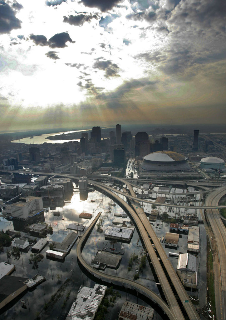
11 a.m.: The eye of the storm is ashore near the Louisiana—-Mississippi Border. Katrina's strongest winds have slowed to 125 miles an hour. The front—right quadrant of the storm, containing the strongest winds and storms, slams into Biloxi and Gulfport with "devastating force" destroying both cities. The major levee in New Orleans fails and water pours into the 17th Street Canal. The entire city is flooding.
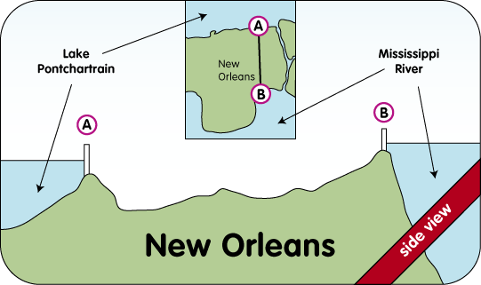
New Orleans was in trouble, because it sits below sea level, like a bowl in the land. when the levees broke, water flooded in and there was no stopping it.
3 p.m.: Katrina's winds have slowed to about 95 miles an hour but the storms she brought still surge and the cities she damaged continue to flood.
THE CALM AFTER THE STORM
WEDNESDAY, AUGUST 31
Michael O. Leavitt, secretary for the Health and Services Department, declares a public health emergency in Louisiana, Mississippi, Alabama, and Florida. All residents are ordered to leave New Orleans, but residents are unable to carry out the order and are left on rooftops and stranded in the Superdome.
THURSDAY, SEPTEMBER 1
2 p.m.: Ray Nagin goes on national television and issues a "desperate SOS" and asks the federal government for help.
FRIDAY, SEPTEMBER 2
A convoy of U.S National Guard troops arrives in New Orleans with supplies. Water, food, and supplies are brought to the residents stranded at the Superdome. Congress approves 10.5 billion dollars in aid for a rescue and relief effort for Hurricane Katrina. President George W. Bush signs the bill. Work rescuing stranded resident, repairing the city's levees, pumping out the floodwaters, and rebuilding homes is already underway.